
01 / 观测 · 过程 · 模型29 篇
积雪水文
观测风吹雪、升华与融雪过程,追踪融雪径流贡献,重建积雪和雪水当量。
揭示长江源区融雪贡献的海拔依赖性存在春季零度层高度阈值;跨越阈值后关系突变,降温虽可使其恢复,却存在多年滞后。
Zixiang Li, Hongyi Li, Weixin Xu, Yaru Yang, Rui He, Yiwei Liu, Yuanbao Feng, Na Dai. (2026). Abrupt shift in elevation-dependent snowmelt contribution in the Central Tibetan Plateau. Journal of Hydrology: Regional Studies, 66, 103634. https://doi.org/10.1016/j.ejrh.2026.103634
将河冰二元识别拓展为四类光谱子类,建立跨流域、跨传感器分类基准,识别可见光亮度与短波红外中的关键区分特征。
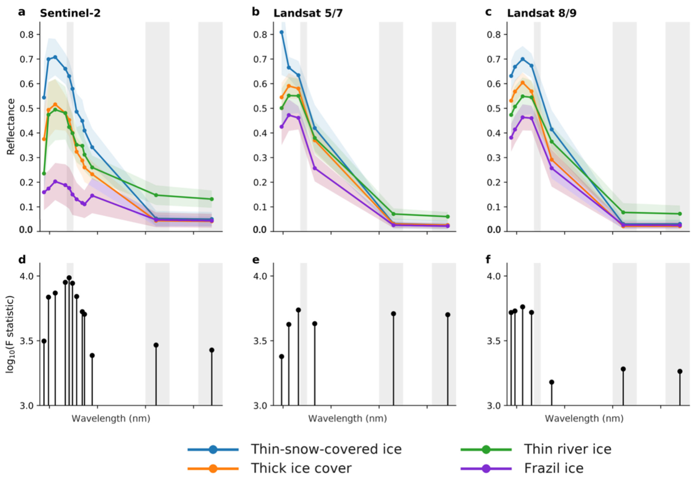
Hanwen Zhang, Hongyi Li. (2026). Optical River Ice Spectral Subclassification on the Tibetan Plateau: A Landsat 5–9 and Sentinel-2 Benchmark with Interpretable Machine Learning. Remote Sensing, 18(9), 1437. https://doi.org/10.3390/rs18091437
比较五种河冰指数并验证双极化 SAR 冰厚反演,明确面积与厚度监测的适用条件,汇集河冰响应气候变暖的证据。
Li, H., Li, H., Zhang, H. and Pang, X. (2026) Remote sensing of river ice under climate change. In: Kelly, R. and Ellias, S. (eds.) Comprehensive Cryospheric Science and Environmental Change. Vol. 3, pp. 298-334. UK: Elsevier. https://doi.org/10.1016/B978-0-323-85242-5.00019-1
提出计入观测不确定性的风吹雪概率分类方法,揭示高原冬季积雪质量变化以风致沉积和侵蚀为主。

Hongyi Li, Tao Che, Yang Zhang. (2025). Wind Shaped Winter Snow Mass Balance at High Altitude: Insights From an Integrated Snow Observation System. Water Resources Research, 61(12), e2025WR039885. https://doi.org/10.1029/2025WR039885
提出小波模式驱动的训练样本选择方法,提高 LSTM 对异常径流的模拟能力,并揭示异常样本比例与常态预测精度的权衡。

Yiwei Liu, Hongyi Li, Yaru Yang, Xin Pang, Liting Niu. (2025). Enhancing machine learning runoff simulation via wavelet-based abnormality pattern recognition. Journal of Hydrology, 661, 133729. https://doi.org/10.1016/j.jhydrol.2025.133729
联合光谱与地形识别河冰,验证随机森林在辫状河道、窄河段和积雪干扰下优于传统指数,并具有跨传感器适用性。
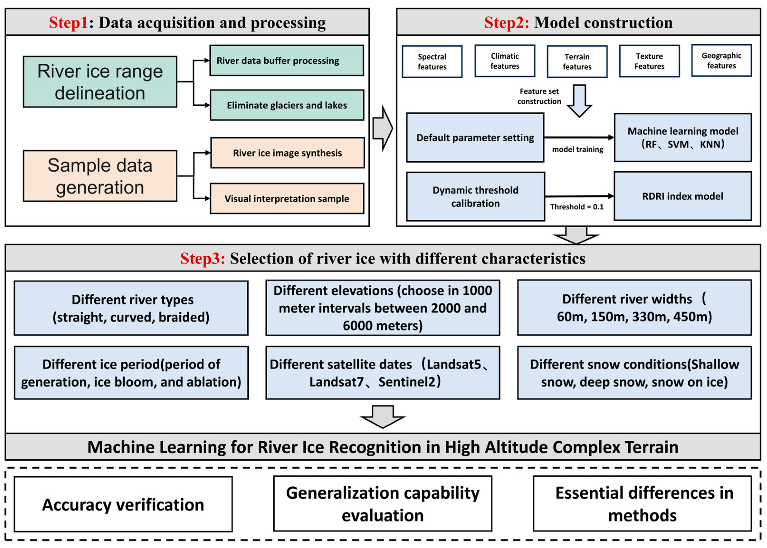
Pang, Xin, Li, Hongyi, Ren, Hongrui, Yang, Yaru, Zhao, Qin, Liu, Yiwei, Hao, Xiaohua, Niu, Liting. (2025). Machine Learning-Enhanced River Ice Identification in the Complex Tibetan Plateau. Remote Sensing, 17(11), 1889. https://doi.org/10.3390/rs17111889
揭示长江源区春季融雪贡献由6月向4—5月前移;1980—2022年融雪期每十年缩短3.3天,同时极端融雪径流事件增多。
Zixiang Li, Weixin Xu, Hongyi Li, Na Dai, Kunlin Huang, Yaru Yang, Lidong Li, Jingke Si. (2025). Runoff contribution of spring snowmelt in the source region of the Yangtze River and its variation characteristics. Journal of Hydrology: Regional Studies, 58, 102295. https://doi.org/10.1016/j.ejrh.2025.102295
联合降水与径流验证,明确寒旱山区产品适用性的差异:ERA5-Land 适于长期变化,IMERG-F 适于极端降水及洪水研究。
Yang Yaru, Ji Wenzheng, Niu Liting, Zheng Zhaojun, Huang Weidong, Zhang Changshun, Hao Xiaohua, Xiao Jianshe, Li Hongyi. (2024). Assessing satellite and reanalysis-based precipitation products in cold and arid mountainous regions. Journal of Hydrology: Regional Studies, 51, 101612. https://doi.org/10.1016/j.ejrh.2023.101612
专题述评将寒区遥感进展联系到水文过程模拟,提出加强不确定性量化、机器学习物理约束和跨区域验证的研究方向。
Li, Hongyi, Hao, Xiaohua, Ran, Youhua, Xiao, Pengfeng. (2024). Monitoring Cold-Region Water Cycles Using Remote Sensing Big Data. Remote Sensing, 16(24), 4752. https://doi.org/10.3390/rs16244752
提出 ICESat-2 轨道交叉点提取算法,构建青藏高原多类地表的局地高程变化数据,以约17米观测足迹补充粗分辨率变化产品。

Tengfei Chen, Jian Wang, Tao Che, Xiaohua Hao, Hongyi Li. (2024). High spatial resolution elevation change dataset derived from ICESat-2 crossover points on the Tibetan Plateau. Scientific Data, 11, 394. https://doi.org/10.1038/s41597-024-03214-2
融合卫星测高、水面范围与调水记录,揭示调水是白洋淀近年水位回升并趋稳的主要驱动,为缺少地面观测的破碎湖区提供补水效益评估方法。
Chen Tengfei, Li Hongyi, Zhao Chunlei, Chang Yufei, Yang Yaru, Wang Jian. (2023). The benefits of the water diversion on a densely populated fragmented lake area — A remote sensing view. Environmental Research Communications, 5(6), 065015. https://doi.org/10.1088/2515-7620/acdfae
用卫星降水辅助 XGBoost 纠正高海拔雨雪漏测,减轻对现场风速观测的依赖,并在跨国家站点检验中改善方法的可迁移性。
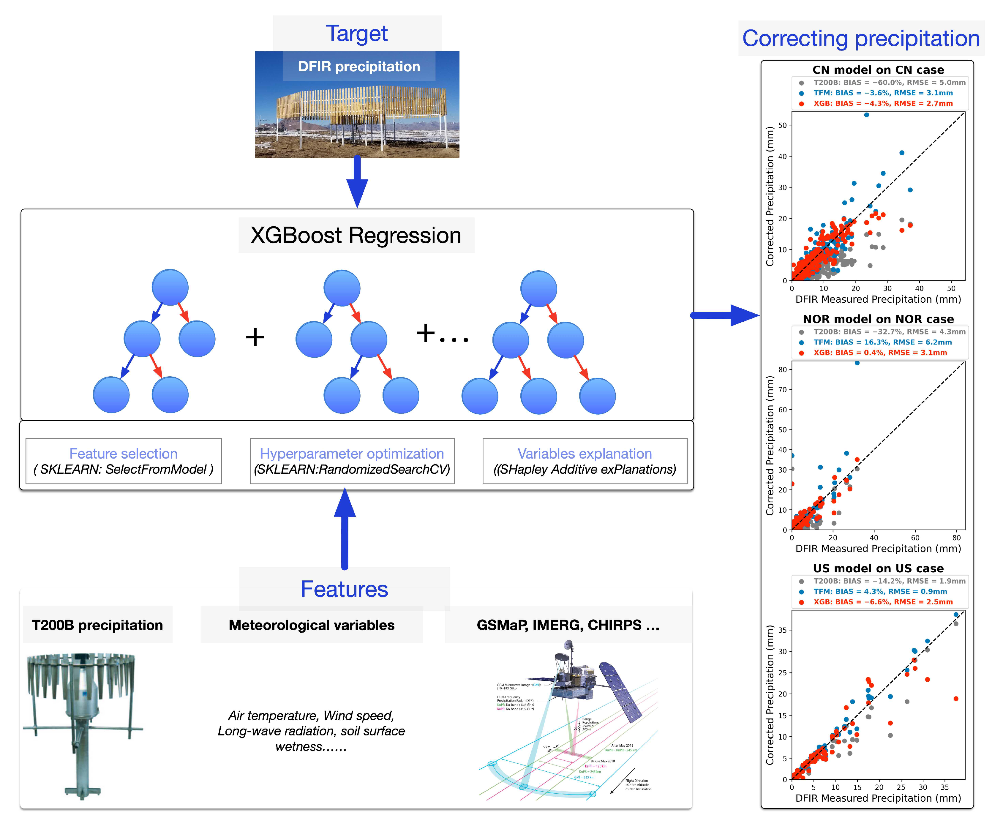
Li Hongyi, Zhang Yang, Lei Huajin, Hao Xiaohua. (2023). Machine Learning-Based Bias Correction of Precipitation Measurements at High Altitude. Remote Sensing, 15(8), 2180. https://doi.org/10.3390/rs15082180
利用双卫星重叠轨道加密观测,解析高原河冰冻融过程;发现断流河段冰期更长,辫状河道由低流速支汊先冻结。
Li Haojie, Li Hongyi, Wang Jian, Hao Xiaohua. (2023). Revealing the river ice phenology on the Tibetan Plateau using Sentinel-2 and Landsat 8 overlapping orbit imagery. Journal of Hydrology, 619, 129285. https://doi.org/10.1016/j.jhydrol.2023.129285
耦合 CMIP6 与生态水文模型建立雪场气候风险评估方法,估算张家口赛区2021—2050年平均每年至少需49天辅助造雪。
Shao Donghang, Li Hongyi, Wang Jian, Hao Xiaohua, Niu Liting. (2023). Adaptability analysis of snow in the Zhangjiakou competition zone of the Beijing Olympic Winter Games for the next 30 years. Journal of Hydrology: Regional Studies, 46, 101358. https://doi.org/10.1016/j.ejrh.2023.101358
将遥感积雪约束引入分布式模拟,提供黑河上游2000—2015年逐日雪水当量、融雪径流及年度贡献系数,连接积雪储量与流域产流评估。
NIU Liting, LI Hongyi, WANG Jian. (2022). A dataset of snow cover water resources in the upper reaches of Heihe River Basin during 2000–2015. China Scientific Data, 7(3). https://doi.org/10.11922/11-6035.ncdc.2021.0035.zh
提供张家口冬奥赛区2021—2050年、1公里分辨率的积雪物候预测数据,将未来雪季变化转化为可供场地评估的空间信息。
YANG Yaru, ZHAO Chunlei, LI Hongyi, SHAO Donghang, JI Wenzheng. (2022). A dataset of snow cover phenology for the next 30 years in Zhangjiakou Venue Cluster of the Olympics Winter Games Beijing 2022. China Scientific Data, 7(3), 70-83. https://doi.org/10.11922/11-6035.ncdc.2021.0023.zh
量化青藏高原东北部雪季降水的陆地水汽主导格局:1979—2017年约92%来自陆地,其中约66%来自研究区之外的高原地区。
Wang Weiguo, Li Hongyi, Xie Zeming, Zhu Xiaofan, Xiao Linhong, Hao Xiaohua, Wang Jian. (2022). Continental Water Vapor Dominantly Impacts Precipitation during the Snow Season on the Northeastern Tibetan Plateau. Journal of Climate, 35(12), 3819-3831. https://doi.org/10.1175/jcli-d-21-0241.1
将双极化 C 波段 SAR 冰厚反演拓展至高原窄河道,并揭示河流走向与升降轨的匹配关系会影响反演精度。
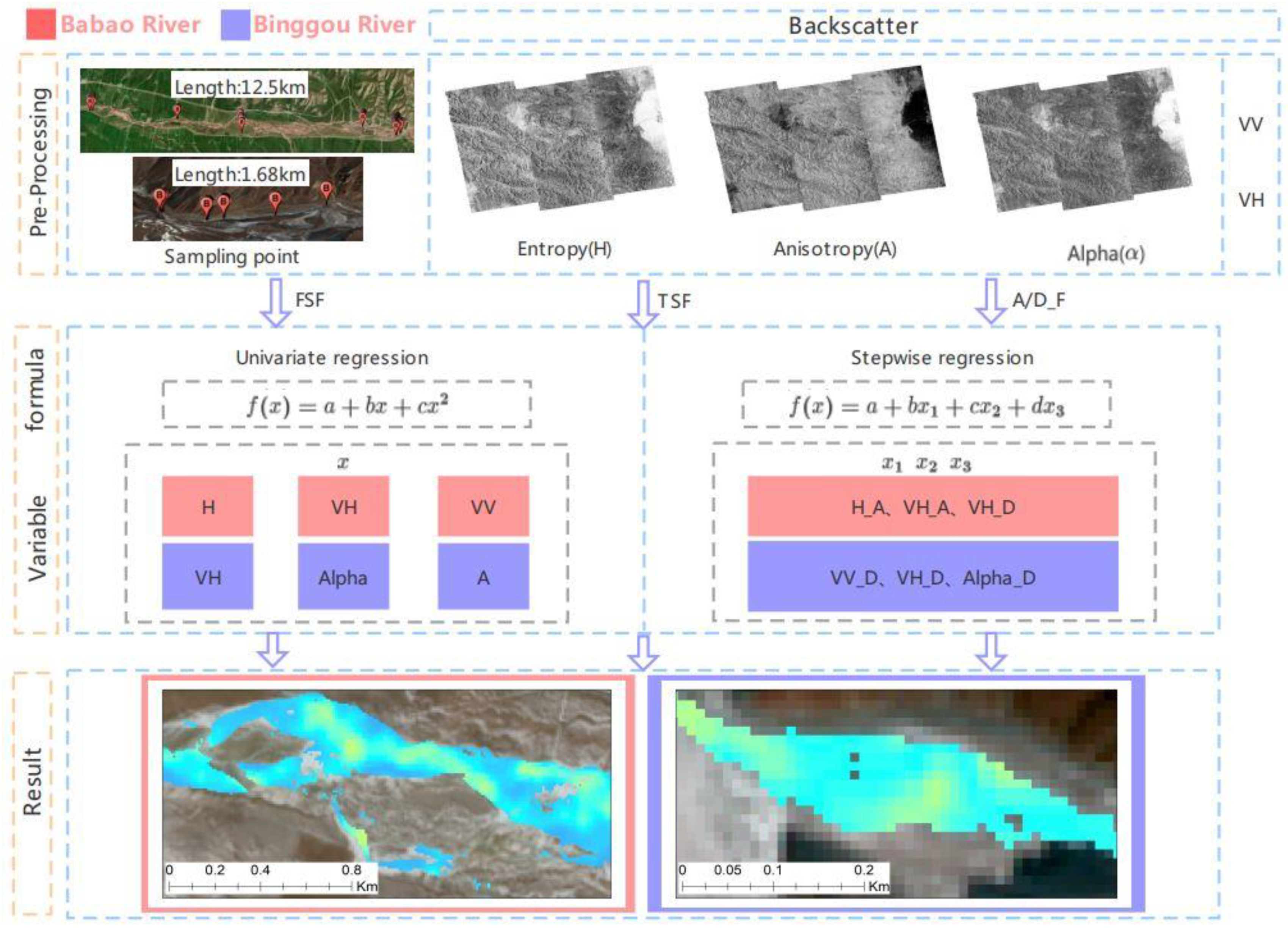
Zhang Huan, Li Hongyi, Li Haojie. (2022). Monitoring the Ice Thickness in High-Order Rivers on the Tibetan Plateau with Dual-Polarized C-Band Synthetic Aperture Radar. Remote Sensing, 14(11), 2591. https://doi.org/10.3390/rs14112591
以岭回归融合多套产品与海拔信息,生成45°N以北无时空缺口的逐日雪水当量,实测验证精度优于各源产品。
Shao Donghang, Li Hongyi, Wang Jian, Hao Xiaohua, Che Tao, Ji Wenzheng. (2022). Reconstruction of a daily gridded snow water equivalent product for the land region above 45° N based on a ridge regression machine learning approach. Earth System Science Data, 14(2), 795-809. https://doi.org/10.5194/essd-14-795-2022
联合风致漏测订正和频率分布优化,发布1980—2009年青藏高原10公里逐日降水,保留稀疏观测插值中易被平滑的变率。
马佳培, 李弘毅. (2022). 改进频率分布和风速纠正的青藏高原格点降水数据集(1980~2009年). 遥感技术与应用, 37(2), 507-514.
提出综合红光、近红外与短波红外差异的 RDRI 指数,改善传统指数混淆河冰与积雪的问题,扩展高原河冰的大范围识别。
Li Haojie, Li Hongyi, Wang Jian, Hao Xiaohua. (2021). Identifying river ice on the Tibetan Plateau based on the relative difference in spectral bands. Journal of Hydrology, 601, 126613. https://doi.org/10.1016/j.jhydrol.2021.126613
通过七套产品的分地形比较,揭示青藏高原东部降水估计误差的地形依赖性,以及极端降水识别能力弱于小量级降水的共同不足。
Lei Huajin, Li Hongyi, Zhao Hongyu, Ao Tianqi, Li Xiaodong. (2021). Comprehensive evaluation of satellite and reanalysis precipitation products over the eastern Tibetan plateau characterized by a high diversity of topographies. Atmospheric Research, 259, 105661. https://doi.org/10.1016/j.atmosres.2021.105661
以机载 LiDAR 统一验证山区高程产品,发现冰沟流域 ICESat-2 ATL06 的均方根误差为0.747米,坡度是主要误差控制因素。
张欢, 李弘毅, 李浩杰, 车涛. (2021). LiDAR 的高寒山区遥感高程数据精度评估. 遥感技术与应用, 36(6), 1311-1320. https://doi.org/10.11873/j.issn.1004-0323.2021.6.1311
联合风致漏测订正与海拔约束插值,减少格点降水的分布误差,抑制稀疏观测插值对极端值和时间方差的平滑。

Ma Jiapei, Li Hongyi, Wang Jian, Hao Xiaohua, Shao Donghang, Lei Huajin. (2020). Reducing the Statistical Distribution Error in Gridded Precipitation Data for the Tibetan Plateau. Journal of Hydrometeorology, 21(11), 2641-2654. https://doi.org/10.1175/jhm-d-20-0096.1
将辐射传输嵌入陆面模型,把积雪反照率模拟扩展到卫星可直接观测的连续短波光谱,并可推算遥感缺测期的光谱变化。

Shao Donghang, Xu Wenbo, Li Hongyi, Wang Jian, Hao Xiaohua. (2020). Modeling Snow Surface Spectral Reflectance in a Land Surface Model Targeting Satellite Remote Sensing Observations. Remote Sensing, 12(18), 3101. https://doi.org/10.3390/rs12183101
重建八宝河1999—2018年河冰分布,发现河冰面积略减且与气温负相关,河冰更易分布于高海拔、缓坡河段。

Li Haojie, Li Hongyi, Wang Jian, Hao Xiaohua. (2020). Monitoring high-altitude river ice distribution at the basin scale in the northeastern Tibetan Plateau from a Landsat time-series spanning 1999–2018. Remote Sensing of Environment, 247, 111915. https://doi.org/10.1016/j.rse.2020.111915
量化北疆雪季降水的水汽源贡献,识别西欧亚大陆约48%的主导份额,并将1980—2017年降水增多与西欧亚、北极水汽输入增强联系起来。
Wang Weiguo, Li Hongyi, Wang Jian, Hao Xiaohua. (2020). Water Vapor from Western Eurasia Promotes Precipitation during the Snow Season in Northern Xinjiang, a Typical Arid Region in Central Asia. Water, 12(1), 141. https://doi.org/10.3390/w12010141
系统区分光学与微波对河冰范围、物候和厚度的观测能力,提出多传感器联合及遥感—水文模型协同的研究方向。
李浩杰, 李弘毅, 王建, 郝晓华. (2020). 河冰遥感监测研究进展. 地球科学进展, 35(10), 1041-1051. https://doi.org/10.11867/j.issn.1001-8166.2020.081
提出分段分位数映射,单独订正极端降水;在黑河上游,订正后 WRF 年降水空间相关系数由0.74提高至0.94。
雷华锦, 马佳培, 李弘毅, 王建, 邵东航, 赵宏宇. (2020). 基于分位数映射法的黑河上游气候模式降水误差订正. 高原气象, 39(2), 266-279. https://doi.org/10.7522/j.issn.1000-0534.2019.00104
杨大文, 郑元润, 高冰, 李弘毅, 于澎涛. (2020). 高寒山区生态水文过程与耦合模拟. 科学出版社.
将地形、植被和地表温度引入自适应回归,改进青藏高原 MODIS 积雪面积比例估计,均方根误差由原产品的0.221降至0.103。
雷华锦, 李弘毅, 王建, 郝晓华, 赵宏宇, 张娟. (2020). 基于环境信息和回归模型的青藏高原MODIS积雪面积比例产品制备. 遥感技术与应用, 35(6), 1303-1311. https://doi.org/10.11873/j.issn.1004-0323.2020.6.1303
提出近红外多像元比值法,将流量遥感从大河扩展至宽度大于30米的小河流,并验证其在无站流域的应用潜力。
Li Haojie, Li Hongyi, Wang Jian, Hao Xiaohua. (2019). Extending the Ability of Near‐Infrared Images to Monitor Small River Discharge on the Northeastern Tibetan Plateau. Water Resources Research, 55(11), 8404-8421. https://doi.org/10.1029/2018wr023808
建立融雪水在径流、土壤和蒸发间的路径追踪方法,揭示黑河上游融雪经土壤滞蓄可在无雪期乃至次年持续补给径流。
Li Hongyi, Li Xin, Yang Dawen, Wang Jian, Gao Bing, Pan Xiaoduo, Zhang Yanlin, Hao Xiaohua. (2019). Tracing Snowmelt Paths in an Integrated Hydrological Model for Understanding Seasonal Snowmelt Contribution at Basin Scale. Journal of Geophysical Research: Atmospheres, 124(16), 8874-8895. https://doi.org/10.1029/2019jd030760
验证 Priestley–Taylor 土壤—冠层温度分解可改善绿洲潜热估计:相较线性分解法,双源能量平衡模型的均方根误差降低约39%。
Wang Runke, Wang Jian, Zhu Gaofeng, Li Hongyi, Shao Donghang, Hao Xiaohua. (2019). Estimation of surface latent heat fluxes in an oasis utilizing a two-source energy balance model based on land surface temperature decomposition. Journal of Applied Remote Sensing, 13(3), 034504. https://doi.org/10.1117/1.jrs.13.034504
Li Haojie, Li Hongyi, Wang Jian. (2019). Area Change of Snow and Ice in the Babao River Basin, Tibetan Plateau. IGARSS 2019 - 2019 IEEE International Geoscience and Remote Sensing Symposium, 4084-4087. https://doi.org/10.1109/igarss.2019.8898368
Wang Weiguo, Li Hongyi, Wang Jian. (2019). Precipitation Change During the Snow Period in The Northern Xinjiang, a Typical Arid Region. IGARSS 2019 - 2019 IEEE International Geoscience and Remote Sensing Symposium, 7770-7773. https://doi.org/10.1109/igarss.2019.8898767
在伽马射线雪水当量反演中校正土壤水分扰动并标定区域参数,使连续无损观测更接近实测积雪储量。
Ma Yuan, Li Hongyi, Wang Jian, Hao Xiaohua. (2019). Retrieval of Snow Water Equivalent by Gamma. IGARSS 2019 - 2019 IEEE International Geoscience and Remote Sensing Symposium, 4121-4124. https://doi.org/10.1109/igarss.2019.8900393
马佳培, 李弘毅, 王建, 邵东航. (2019). 面向寒区水文模拟的区域气候模式降水订正方法对比. 遥感技术与应用, 34(3), 655-666.
以物理正向模拟补足遥感缺测,再与反演模型联合重建积雪反照率,减轻云遮挡和单一模型误差对长时间序列的影响。
Shao Donghang, Xu Wenbo, Li Hongyi, Wang Jian, Hao Xiaohua. (2018). Reconstruction of Remotely Sensed Snow Albedo for Quality Improvements Based on a Combination of Forward and Retrieval Models. IEEE Transactions on Geoscience and Remote Sensing, 56(12), 6969-6985. https://doi.org/10.1109/tgrs.2018.2846681
联合质量—能量观测与模型诊断,识别高海拔降雪漏测及风致雪量变化,指出一维积雪模型在强风条件下的局限。
Hongyi Li, Xin Li, Jian Wang, Ning Huang. (2018). Understanding snow processes in high mountainous region: Observation system and integrated model. SnowHydro 2018 – International Conference on Snow Hydrology, Heidelberg.
发现祁连山风速与积雪覆盖在约3900米以下正相关、以上负相关,为风将高处积雪向低处输送提供空间证据。

Shao Donghang, Li Hongyi, Wang Jian, Pan Xiaoduo, Hao Xiaohua. (2017). Distinguishing the Role of Wind in Snow Distribution by Utilizing Remote Sensing and Modeling Data: Case Study in the Northeastern Tibetan Plateau. IEEE Journal of Selected Topics in Applied Earth Observations and Remote Sensing, 10(10), 4445-4456. https://doi.org/10.1109/jstars.2017.2716388
将土壤含水量变化与区域参数标定纳入伽马射线雪水当量反演,减少下垫面干扰,在阿勒泰验证期取得0.99的纳什效率系数。
马媛, 李弘毅, 张璞, 刘大锋, 黄晓东, 郝晓华, 邵东航, 王建. (2017). 利用伽马射线探测雪水当量方法的改进. 遥感技术与应用, 32(1), 57-63.
利用 ART 校正积雪反射的各向异性,验证其反照率估计优于 MOD10A1,并揭示山地尺度效应带来的精度差异。
邵东航, 李弘毅, 王建, 郝晓华, 王润科, 马媛. (2017). 基于多源遥感数据的积雪反照率反演研究. 遥感技术与应用, 32(1), 71-77.
李弘毅, 李晶, 戴礼云, 王建. (2016). 中国西部积雪水资源. 气候变化影响与风险. 科学出版社, 第7章.
将温度与辐射驱动的非均匀消融引入空间分配,把500米积雪比例降尺度至30米,恢复粗像元中积雪的具体位置。
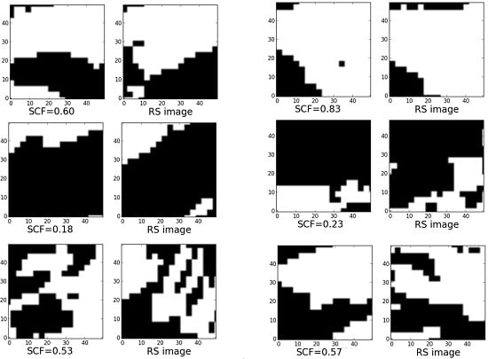
Hong Yi Li, Yong Qi He, Xiao Hua Hao, Tao Che, Jian Wang, Xiao Dong Huang. (2015). Downscaling Snow Cover Fraction Data in Mountainous Regions Based on Simulated Inhomogeneous Snow Ablation. Remote Sensing, 7(7), 8995-9019. https://doi.org/10.3390/rs70708995
以集合卡尔曼滤波融合多源遥感与 SnowModel,改善高原浅薄斑块积雪模拟,并发现积雪消退曲线是无站地区分布模拟的关键参数。
Li Hongyi, Tang Zhiguang, Wang Jian, Che Tao, Pan Xiaoduo, Huang Chunlin, Wang Xufeng, Hao Xiaohua, Sun Shaobo. (2014). Synthesis method for simulating snow distribution utilizing remotely sensed data for the Tibetan Plateau. Journal of Applied Remote Sensing, 8(1), 084696. https://doi.org/10.1117/1.jrs.8.084696
量化祁连山风吹雪的升华损失,发现2008年垭口站吹雪升华占总积雪升华的41.5%,揭示风吹雪在雪季耗水中的重要份额。
Li, Hongyi, Wang, Jian, Hao, Xiaohua. (2014). Role of blowing snow in snow processes in Qilian Mountainous region. Sciences in Cold and Arid Regions, 6, 124-130. https://doi.org/10.3724/SP.J.1226.2014.00124
李弘毅, 王建. (2013). 积雪水文模拟中的关键问题及其研究进展. 冰川冻土, 35(2), 430-437.
将能量平衡模拟与云下积雪面积插值结合,重建完整积雪期的空间雪量和消融径流,缓解多云高山流域遥感不连续的问题。
Li H.-Y., Wang J. (2011). Simulation of snow distribution and melt under cloudy conditions in an Alpine watershed. Hydrology and Earth System Sciences, 15(7), 2195-2203. https://doi.org/10.5194/hess-15-2195-2011
李弘毅, 王建, 白云洁, 李哲. (2009). 黑河上游冰沟流域典型积雪期水文情势. 冰川冻土, 31(2), 293-300.
将雪面与吹雪升华共同纳入概率估算,并通过冰沟流域积雪损失观测验证,改进强风高寒流域的积雪耗水估计。
Li HY, Wang J, Li Z. (2009). Estimation of snow sublimation under a high-speed wind condition in alpine region watershed. Journal of Sichuan University (Engineering Science Edition), 46, 129-136.
李弘毅, 王建. (2008). SRM融雪径流模型在黑河流域上游的模拟研究. 冰川冻土, 30(5), 769-775.