
01 / Observations · Processes · Models29 papers
Snow Hydrology
Observing blowing snow, sublimation and snowmelt, tracing snowmelt contributions to runoff, and reconstructing snow cover and snow water equivalent.
01 / Observations · Processes · Models29 papers
Observing blowing snow, sublimation and snowmelt, tracing snowmelt contributions to runoff, and reconstructing snow cover and snow water equivalent.
02 / Distribution · Phenology · Runoff9 papers
Identifying river ice spectral classes, distribution, phenology and thickness, and combining field observations with satellite-based discharge estimation.
03 / Data · Prediction · Assessment23 papers
Correcting precipitation data, monitoring surface elevation change, assessing snowmelt contributions, and improving runoff simulations for anomalous years.
Identifies a spring freezing-level threshold in the elevation dependence of snowmelt contributions in the Yangtze headwaters. The relationship shifts abruptly across this threshold; cooling can restore it, but with a multi-year lag.
Zixiang Li, Hongyi Li, Weixin Xu, Yaru Yang, Rui He, Yiwei Liu, Yuanbao Feng, Na Dai. (2026). Abrupt shift in elevation-dependent snowmelt contribution in the Central Tibetan Plateau. Journal of Hydrology: Regional Studies, 66, 103634. https://doi.org/10.1016/j.ejrh.2026.103634
Extends binary river ice identification to four spectral subclasses, establishes a classification benchmark across basins and sensors, and identifies key discriminating features in visible brightness and shortwave infrared bands.
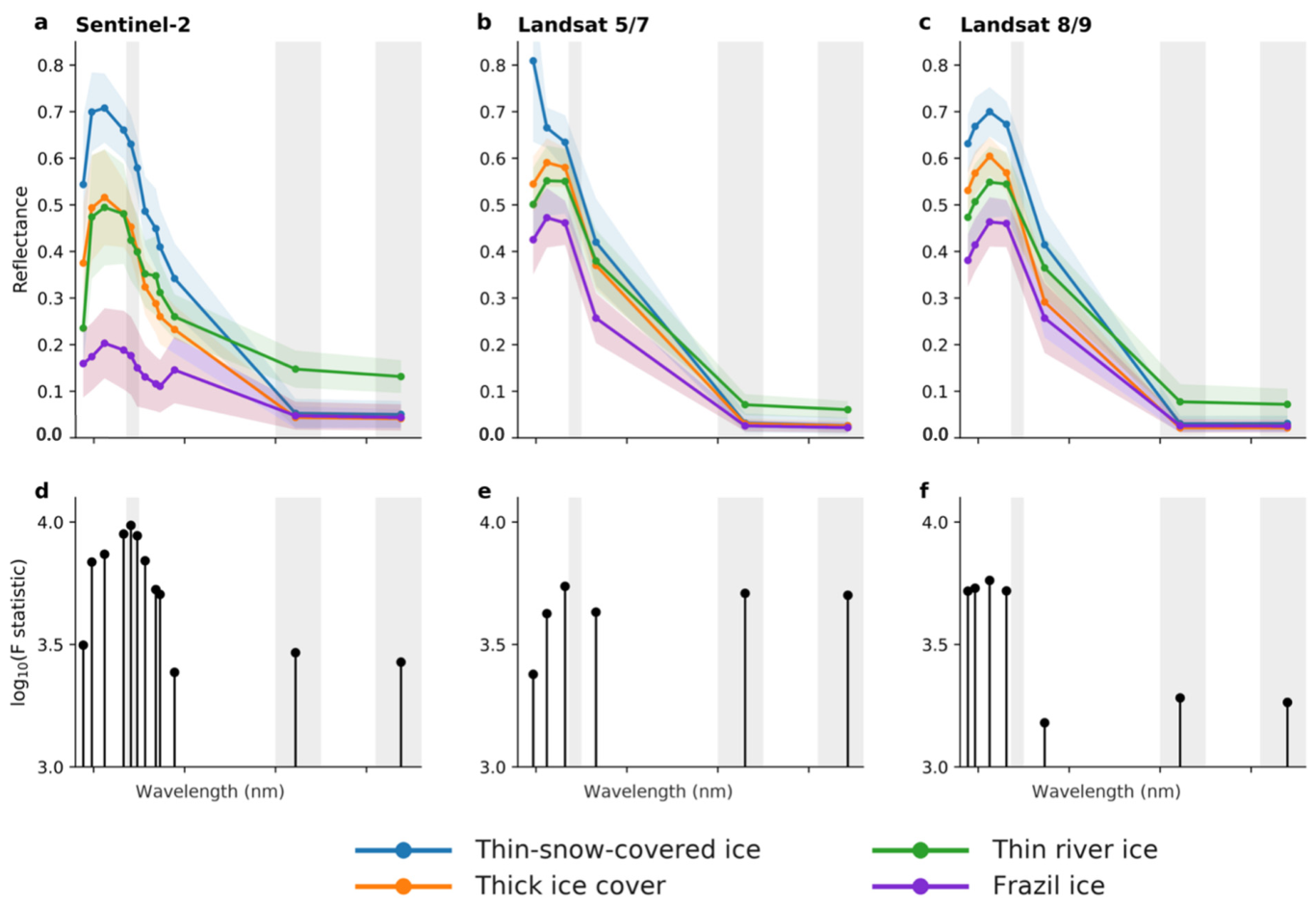
Hanwen Zhang, Hongyi Li. (2026). Optical River Ice Spectral Subclassification on the Tibetan Plateau: A Landsat 5–9 and Sentinel-2 Benchmark with Interpretable Machine Learning. Remote Sensing, 18(9), 1437. https://doi.org/10.3390/rs18091437
Compares five river ice indices and validates dual-polarization SAR ice-thickness retrieval, clarifying conditions for monitoring ice extent and thickness and bringing together evidence of river ice responses to warming.
Li, H., Li, H., Zhang, H. and Pang, X. (2026) Remote sensing of river ice under climate change. In: Kelly, R. and Ellias, S. (eds.) Comprehensive Cryospheric Science and Environmental Change. Vol. 3, pp. 298-334. UK: Elsevier. https://doi.org/10.1016/B978-0-323-85242-5.00019-1
Develops a probabilistic blowing-snow classification method that accounts for observational uncertainty, showing that wind-driven deposition and erosion dominate winter snow mass changes on the plateau.

Hongyi Li, Tao Che, Yang Zhang. (2025). Wind Shaped Winter Snow Mass Balance at High Altitude: Insights From an Integrated Snow Observation System. Water Resources Research, 61(12), e2025WR039885. https://doi.org/10.1029/2025WR039885
Introduces wavelet-pattern-based training-sample selection to improve LSTM simulation of anomalous runoff, revealing a trade-off between the proportion of anomalous samples and prediction accuracy under normal conditions.

Yiwei Liu, Hongyi Li, Yaru Yang, Xin Pang, Liting Niu. (2025). Enhancing machine learning runoff simulation via wavelet-based abnormality pattern recognition. Journal of Hydrology, 661, 133729. https://doi.org/10.1016/j.jhydrol.2025.133729
Combines spectral and topographic information to identify river ice. Random forests outperform conventional indices in braided channels, narrow reaches and snow-affected settings, with applicability across sensors.
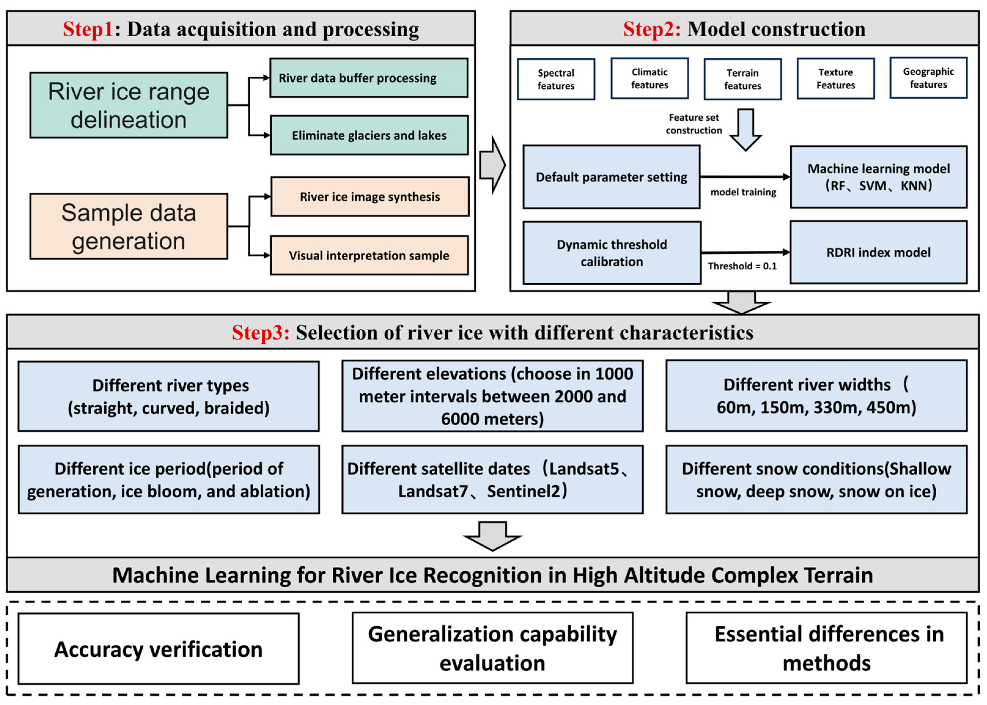
Pang, Xin, Li, Hongyi, Ren, Hongrui, Yang, Yaru, Zhao, Qin, Liu, Yiwei, Hao, Xiaohua, Niu, Liting. (2025). Machine Learning-Enhanced River Ice Identification in the Complex Tibetan Plateau. Remote Sensing, 17(11), 1889. https://doi.org/10.3390/rs17111889
Shows that spring snowmelt contributions in the Yangtze headwaters have shifted from June toward April–May. The melt season shortened by 3.3 days per decade during 1980–2022, while extreme snowmelt-runoff events became more frequent.
Zixiang Li, Weixin Xu, Hongyi Li, Na Dai, Kunlin Huang, Yaru Yang, Lidong Li, Jingke Si. (2025). Runoff contribution of spring snowmelt in the source region of the Yangtze River and its variation characteristics. Journal of Hydrology: Regional Studies, 58, 102295. https://doi.org/10.1016/j.ejrh.2025.102295
Evaluates precipitation and runoff together to distinguish product suitability in cold, arid mountains: ERA5-Land is suited to long-term variability, whereas IMERG-F is suited to extreme precipitation and flood studies.
Yang Yaru, Ji Wenzheng, Niu Liting, Zheng Zhaojun, Huang Weidong, Zhang Changshun, Hao Xiaohua, Xiao Jianshe, Li Hongyi. (2024). Assessing satellite and reanalysis-based precipitation products in cold and arid mountainous regions. Journal of Hydrology: Regional Studies, 51, 101612. https://doi.org/10.1016/j.ejrh.2023.101612
This special-issue review connects advances in cold-region remote sensing with hydrological process modelling, identifying uncertainty quantification, physical constraints on machine learning and cross-region validation as priorities.
Li, Hongyi, Hao, Xiaohua, Ran, Youhua, Xiao, Pengfeng. (2024). Monitoring Cold-Region Water Cycles Using Remote Sensing Big Data. Remote Sensing, 16(24), 4752. https://doi.org/10.3390/rs16244752
Develops an ICESat-2 orbital crossover extraction algorithm to quantify local elevation changes across multiple surface types on the Tibetan Plateau, complementing coarse-resolution products with approximately 17 m observation footprints.

Tengfei Chen, Jian Wang, Tao Che, Xiaohua Hao, Hongyi Li. (2024). High spatial resolution elevation change dataset derived from ICESat-2 crossover points on the Tibetan Plateau. Scientific Data, 11, 394. https://doi.org/10.1038/s41597-024-03214-2
Combines satellite altimetry, water extent and diversion records to show that water diversion drove the recent recovery and stabilization of Baiyangdian water levels, providing an assessment method for fragmented lakes with limited ground observations.
Chen Tengfei, Li Hongyi, Zhao Chunlei, Chang Yufei, Yang Yaru, Wang Jian. (2023). The benefits of the water diversion on a densely populated fragmented lake area — A remote sensing view. Environmental Research Communications, 5(6), 065015. https://doi.org/10.1088/2515-7620/acdfae
Uses satellite precipitation to support XGBoost correction of high-elevation rain and snow undercatch, reducing dependence on on-site wind measurements and improving transferability in tests across stations in different countries.
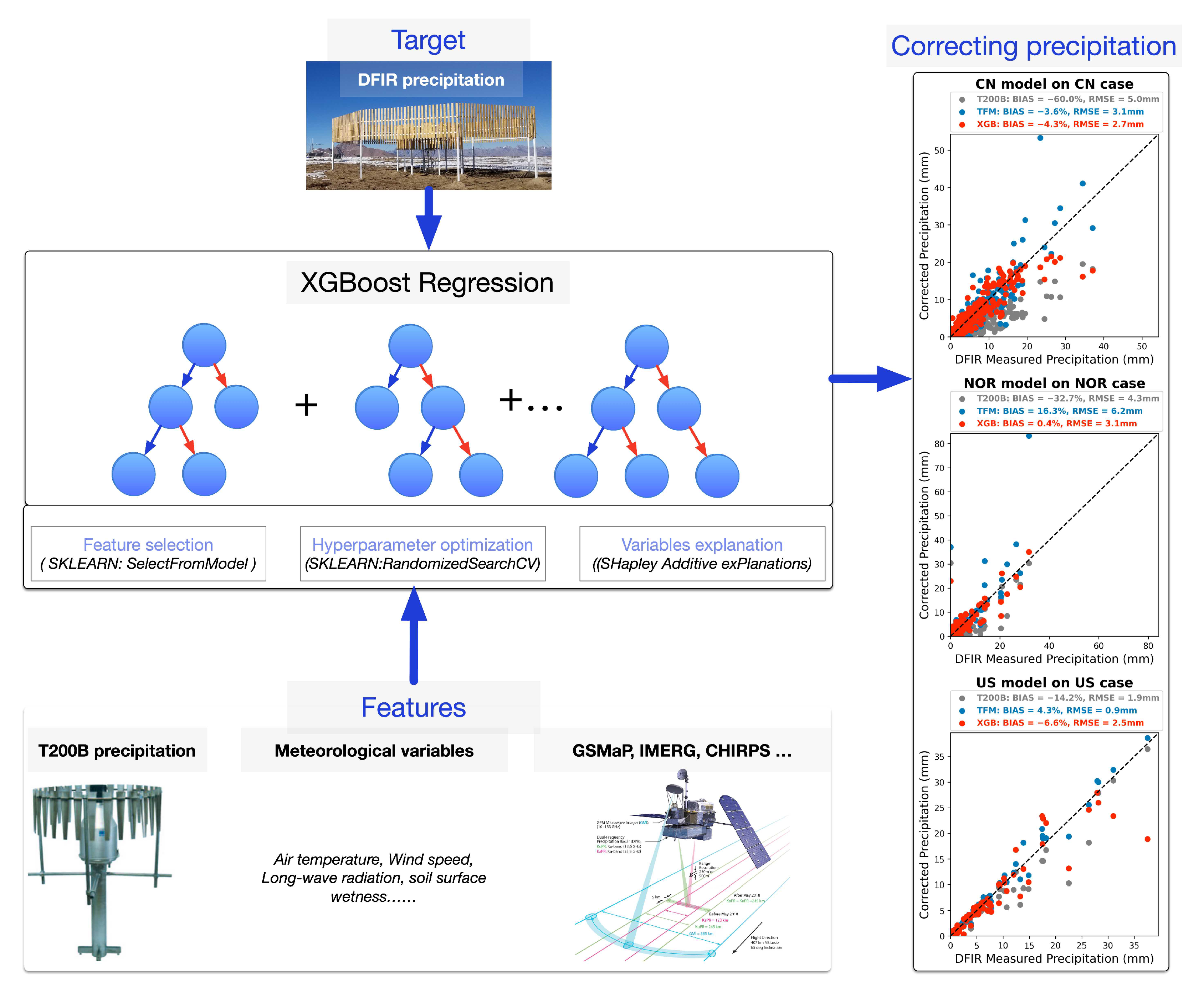
Li Hongyi, Zhang Yang, Lei Huajin, Hao Xiaohua. (2023). Machine Learning-Based Bias Correction of Precipitation Measurements at High Altitude. Remote Sensing, 15(8), 2180. https://doi.org/10.3390/rs15082180
Uses overlapping orbits of two satellites to increase observation frequency and resolve river ice freeze–thaw processes on the plateau. Disconnected reaches have longer ice seasons, and slower-flowing branches freeze first in braided channels.
Li Haojie, Li Hongyi, Wang Jian, Hao Xiaohua. (2023). Revealing the river ice phenology on the Tibetan Plateau using Sentinel-2 and Landsat 8 overlapping orbit imagery. Journal of Hydrology, 619, 129285. https://doi.org/10.1016/j.jhydrol.2023.129285
Couples CMIP6 with an ecohydrological model to assess ski-area climate risk, estimating that Zhangjiakou venues will require supplemental snowmaking for at least 49 days per year on average during 2021–2050.
Shao Donghang, Li Hongyi, Wang Jian, Hao Xiaohua, Niu Liting. (2023). Adaptability analysis of snow in the Zhangjiakou competition zone of the Beijing Olympic Winter Games for the next 30 years. Journal of Hydrology: Regional Studies, 46, 101358. https://doi.org/10.1016/j.ejrh.2023.101358
Constrains distributed simulations with remotely sensed snow cover to provide daily snow water equivalent, snowmelt runoff and annual contribution coefficients for the upper Heihe during 2000–2015, linking snow storage to catchment runoff assessment.
NIU Liting, LI Hongyi, WANG Jian. (2022). A dataset of snow cover water resources in the upper reaches of Heihe River Basin during 2000–2015. China Scientific Data, 7(3). https://doi.org/10.11922/11-6035.ncdc.2021.0035.zh
Provides 1 km snow-phenology projections for Zhangjiakou Winter Olympic venues during 2021–2050, translating future changes in the snow season into spatial information for site assessment.
YANG Yaru, ZHAO Chunlei, LI Hongyi, SHAO Donghang, JI Wenzheng. (2022). A dataset of snow cover phenology for the next 30 years in Zhangjiakou Venue Cluster of the Olympics Winter Games Beijing 2022. China Scientific Data, 7(3), 70-83. https://doi.org/10.11922/11-6035.ncdc.2021.0023.zh
Quantifies the dominance of continental moisture in northeastern Tibetan Plateau snow-season precipitation: about 92% originated over land during 1979–2017, including about 66% from plateau areas outside the study region.
Wang Weiguo, Li Hongyi, Xie Zeming, Zhu Xiaofan, Xiao Linhong, Hao Xiaohua, Wang Jian. (2022). Continental Water Vapor Dominantly Impacts Precipitation during the Snow Season on the Northeastern Tibetan Plateau. Journal of Climate, 35(12), 3819-3831. https://doi.org/10.1175/jcli-d-21-0241.1
Extends dual-polarization C-band SAR ice-thickness retrieval to narrow plateau rivers and shows that the alignment of river orientation with ascending or descending orbits affects retrieval accuracy.
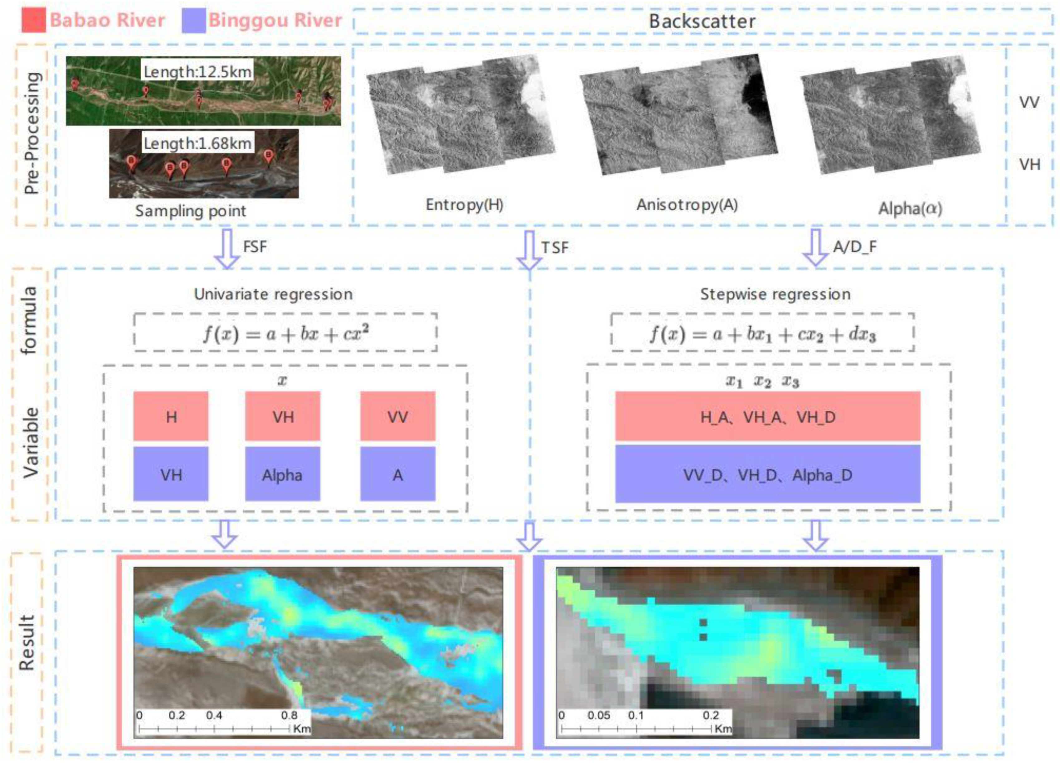
Zhang Huan, Li Hongyi, Li Haojie. (2022). Monitoring the Ice Thickness in High-Order Rivers on the Tibetan Plateau with Dual-Polarized C-Band Synthetic Aperture Radar. Remote Sensing, 14(11), 2591. https://doi.org/10.3390/rs14112591
Combines multiple products and elevation information using ridge regression to produce gap-free daily snow water equivalent north of 45°N, with ground validation showing higher accuracy than the individual source products.
Shao Donghang, Li Hongyi, Wang Jian, Hao Xiaohua, Che Tao, Ji Wenzheng. (2022). Reconstruction of a daily gridded snow water equivalent product for the land region above 45° N based on a ridge regression machine learning approach. Earth System Science Data, 14(2), 795-809. https://doi.org/10.5194/essd-14-795-2022
Combines wind-induced undercatch correction with frequency-distribution optimization to provide 10 km daily precipitation over the Tibetan Plateau for 1980–2009, preserving variability often smoothed by interpolation of sparse observations.
Ma Jiapei, Li Hongyi. (2022). A Gridded Precipitation Dataset for the Tibetan Plateau with Improved Frequency Distribution and Wind Correction (1980–2009) [in Chinese]. Remote Sensing Technology and Application, 37(2), 507-514.
Introduces the RDRI index, integrating differences among red, near-infrared and shortwave-infrared bands to reduce confusion between river ice and snow in conventional indices and expand large-scale river ice identification on the plateau.
Li Haojie, Li Hongyi, Wang Jian, Hao Xiaohua. (2021). Identifying river ice on the Tibetan Plateau based on the relative difference in spectral bands. Journal of Hydrology, 601, 126613. https://doi.org/10.1016/j.jhydrol.2021.126613
Compares seven products across terrain classes, revealing topographic dependence in precipitation errors over the eastern Tibetan Plateau and a shared weakness in detecting extremes relative to smaller precipitation events.
Lei Huajin, Li Hongyi, Zhao Hongyu, Ao Tianqi, Li Xiaodong. (2021). Comprehensive evaluation of satellite and reanalysis precipitation products over the eastern Tibetan plateau characterized by a high diversity of topographies. Atmospheric Research, 259, 105661. https://doi.org/10.1016/j.atmosres.2021.105661
Uses airborne LiDAR as a common reference for mountain elevation products. ICESat-2 ATL06 has a root-mean-square error of 0.747 m in the Binggou catchment, with slope as the primary control on error.
Zhang Huan, Li Hongyi, Li Haojie, Che Tao. (2021). Accuracy Assessment of Remotely Sensed Elevation Data in Alpine Mountains Using LiDAR [in Chinese]. Remote Sensing Technology and Application, 36(6), 1311-1320. https://doi.org/10.11873/j.issn.1004-0323.2021.6.1311
Combines wind-induced undercatch correction with elevation-constrained interpolation to reduce distribution errors in gridded precipitation and limit the smoothing of extremes and temporal variance caused by sparse observations.

Ma Jiapei, Li Hongyi, Wang Jian, Hao Xiaohua, Shao Donghang, Lei Huajin. (2020). Reducing the Statistical Distribution Error in Gridded Precipitation Data for the Tibetan Plateau. Journal of Hydrometeorology, 21(11), 2641-2654. https://doi.org/10.1175/jhm-d-20-0096.1
Embeds radiative transfer in a land-surface model to extend snow albedo simulation to continuous shortwave spectra directly observable by satellites, including estimates of spectral changes during remote sensing data gaps.

Shao Donghang, Xu Wenbo, Li Hongyi, Wang Jian, Hao Xiaohua. (2020). Modeling Snow Surface Spectral Reflectance in a Land Surface Model Targeting Satellite Remote Sensing Observations. Remote Sensing, 12(18), 3101. https://doi.org/10.3390/rs12183101
Reconstructs river ice distribution in the Babao River during 1999–2018. Ice area declined slightly and was negatively correlated with air temperature; ice occurred more frequently in high-elevation, gently sloping reaches.

Li Haojie, Li Hongyi, Wang Jian, Hao Xiaohua. (2020). Monitoring high-altitude river ice distribution at the basin scale in the northeastern Tibetan Plateau from a Landsat time-series spanning 1999–2018. Remote Sensing of Environment, 247, 111915. https://doi.org/10.1016/j.rse.2020.111915
Quantifies moisture-source contributions to snow-season precipitation in northern Xinjiang, identifying a dominant western Eurasian land contribution of about 48% and linking precipitation increases during 1980–2017 to stronger western Eurasian and Arctic moisture inputs.
Wang Weiguo, Li Hongyi, Wang Jian, Hao Xiaohua. (2020). Water Vapor from Western Eurasia Promotes Precipitation during the Snow Season in Northern Xinjiang, a Typical Arid Region in Central Asia. Water, 12(1), 141. https://doi.org/10.3390/w12010141
Systematically distinguishes optical and microwave capabilities for observing river ice extent, phenology and thickness, and proposes multi-sensor integration and closer coupling of remote sensing with hydrological models.
Li Haojie, Li Hongyi, Wang Jian, Hao Xiaohua. (2020). Advances in Remote Sensing of River Ice [in Chinese]. Advances in Earth Science, 35(10), 1041-1051. https://doi.org/10.11867/j.issn.1001-8166.2020.081
Introduces segmented quantile mapping to correct extreme precipitation separately. In the upper Heihe, correction raises the spatial correlation of annual WRF precipitation from 0.74 to 0.94.
Lei Huajin, Ma Jiapei, Li Hongyi, Wang Jian, Shao Donghang, Zhao Hongyu. (2020). Bias Correction of Climate-Model Precipitation in the Upper Heihe River Basin Using Quantile Mapping [in Chinese]. Plateau Meteorology, 39(2), 266-279. https://doi.org/10.7522/j.issn.1000-0534.2019.00104
Yang Dawen, Zheng Yuanrun, Gao Bing, Li Hongyi, Yu Pengtao. (2020). Ecohydrological Processes and Coupled Modelling in Alpine Mountains [in Chinese]. Science Press.
Incorporates terrain, vegetation and land-surface temperature into adaptive regression to improve MODIS fractional snow-cover estimates on the Tibetan Plateau, reducing root-mean-square error from 0.221 to 0.103.
Lei Huajin, Li Hongyi, Wang Jian, Hao Xiaohua, Zhao Hongyu, Zhang Juan. (2020). Development of a MODIS Fractional Snow-Cover Product for the Tibetan Plateau Using Environmental Information and Regression Models [in Chinese]. Remote Sensing Technology and Application, 35(6), 1303-1311. https://doi.org/10.11873/j.issn.1004-0323.2020.6.1303
Introduces a near-infrared multi-pixel ratio method that extends discharge remote sensing from large rivers to small rivers wider than 30 m, demonstrating potential for ungauged basins.
Li Haojie, Li Hongyi, Wang Jian, Hao Xiaohua. (2019). Extending the Ability of Near‐Infrared Images to Monitor Small River Discharge on the Northeastern Tibetan Plateau. Water Resources Research, 55(11), 8404-8421. https://doi.org/10.1029/2018wr023808
Tracks snowmelt pathways among runoff, soil and evaporation, revealing that soil storage in the upper Heihe can sustain snowmelt contributions to runoff during snow-free periods and even into the following year.
Li Hongyi, Li Xin, Yang Dawen, Wang Jian, Gao Bing, Pan Xiaoduo, Zhang Yanlin, Hao Xiaohua. (2019). Tracing Snowmelt Paths in an Integrated Hydrological Model for Understanding Seasonal Snowmelt Contribution at Basin Scale. Journal of Geophysical Research: Atmospheres, 124(16), 8874-8895. https://doi.org/10.1029/2019jd030760
Shows that Priestley–Taylor decomposition of soil and canopy temperatures improves oasis latent-heat estimates, reducing the root-mean-square error of a two-source energy-balance model by about 39% relative to linear decomposition.
Wang Runke, Wang Jian, Zhu Gaofeng, Li Hongyi, Shao Donghang, Hao Xiaohua. (2019). Estimation of surface latent heat fluxes in an oasis utilizing a two-source energy balance model based on land surface temperature decomposition. Journal of Applied Remote Sensing, 13(3), 034504. https://doi.org/10.1117/1.jrs.13.034504
Li Haojie, Li Hongyi, Wang Jian. (2019). Area Change of Snow and Ice in the Babao River Basin, Tibetan Plateau. IGARSS 2019 - 2019 IEEE International Geoscience and Remote Sensing Symposium, 4084-4087. https://doi.org/10.1109/igarss.2019.8898368
Wang Weiguo, Li Hongyi, Wang Jian. (2019). Precipitation Change During the Snow Period in The Northern Xinjiang, a Typical Arid Region. IGARSS 2019 - 2019 IEEE International Geoscience and Remote Sensing Symposium, 7770-7773. https://doi.org/10.1109/igarss.2019.8898767
Corrects soil-moisture disturbances and calibrates regional parameters in gamma-ray retrieval of snow water equivalent, bringing continuous, nondestructive observations closer to measured snow storage.
Ma Yuan, Li Hongyi, Wang Jian, Hao Xiaohua. (2019). Retrieval of Snow Water Equivalent by Gamma. IGARSS 2019 - 2019 IEEE International Geoscience and Remote Sensing Symposium, 4121-4124. https://doi.org/10.1109/igarss.2019.8900393
Ma Jiapei, Li Hongyi, Wang Jian, Shao Donghang. (2019). Comparison of Regional Climate-Model Precipitation Correction Methods for Cold-Region Hydrological Modelling [in Chinese]. Remote Sensing Technology and Application, 34(3), 655-666.
Uses physical forward simulations to fill remote sensing gaps and combines them with a retrieval model to reconstruct snow albedo, reducing cloud-related gaps and single-model errors in long time series.
Shao Donghang, Xu Wenbo, Li Hongyi, Wang Jian, Hao Xiaohua. (2018). Reconstruction of Remotely Sensed Snow Albedo for Quality Improvements Based on a Combination of Forward and Retrieval Models. IEEE Transactions on Geoscience and Remote Sensing, 56(12), 6969-6985. https://doi.org/10.1109/tgrs.2018.2846681
Combines mass–energy observations with model diagnostics to identify high-elevation snowfall undercatch and wind-driven snow changes, highlighting limitations of one-dimensional snow models under strong winds.
Hongyi Li, Xin Li, Jian Wang, Ning Huang. (2018). Understanding snow processes in high mountainous region: Observation system and integrated model. SnowHydro 2018 – International Conference on Snow Hydrology, Heidelberg.
Finds a positive correlation between wind speed and snow cover below about 3,900 m in the Qilian Mountains and a negative correlation above, providing spatial evidence of wind transport from higher to lower elevations.

Shao Donghang, Li Hongyi, Wang Jian, Pan Xiaoduo, Hao Xiaohua. (2017). Distinguishing the Role of Wind in Snow Distribution by Utilizing Remote Sensing and Modeling Data: Case Study in the Northeastern Tibetan Plateau. IEEE Journal of Selected Topics in Applied Earth Observations and Remote Sensing, 10(10), 4445-4456. https://doi.org/10.1109/jstars.2017.2716388
Accounts for soil-moisture changes and regional parameter calibration in gamma-ray snow water equivalent retrieval, reducing ground-surface interference and achieving a Nash–Sutcliffe efficiency of 0.99 during validation in Altay.
Ma Yuan, Li Hongyi, Zhang Pu, Liu Dafeng, Huang Xiaodong, Hao Xiaohua, Shao Donghang, Wang Jian. (2017). Improving Gamma-Ray Methods for Measuring Snow Water Equivalent [in Chinese]. Remote Sensing Technology and Application, 32(1), 57-63.
Uses ART to correct anisotropic snow reflectance, demonstrating more accurate albedo estimates than MOD10A1 and revealing accuracy differences associated with scale effects in mountains.
Shao Donghang, Li Hongyi, Wang Jian, Hao Xiaohua, Wang Runke, Ma Yuan. (2017). Snow Albedo Retrieval Using Multiple Remote Sensing Data Sources [in Chinese]. Remote Sensing Technology and Application, 32(1), 71-77.
Li Hongyi, Li Jing, Dai Liyun, Wang Jian. (2016). Snow Water Resources in Western China [in Chinese]. Climate Change Impacts and Risks. Science Press, Chapter 7.
Introduces temperature- and radiation-driven heterogeneous ablation into spatial allocation to downscale fractional snow cover from 500 m to 30 m and recover snow locations within coarse pixels.
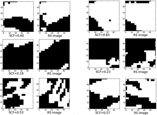
Hong Yi Li, Yong Qi He, Xiao Hua Hao, Tao Che, Jian Wang, Xiao Dong Huang. (2015). Downscaling Snow Cover Fraction Data in Mountainous Regions Based on Simulated Inhomogeneous Snow Ablation. Remote Sensing, 7(7), 8995-9019. https://doi.org/10.3390/rs70708995
Integrates multiple remote sensing sources with SnowModel using an ensemble Kalman filter to improve shallow, patchy snow simulation on the plateau, identifying the snow depletion curve as a key parameter for ungauged regions.
Li Hongyi, Tang Zhiguang, Wang Jian, Che Tao, Pan Xiaoduo, Huang Chunlin, Wang Xufeng, Hao Xiaohua, Sun Shaobo. (2014). Synthesis method for simulating snow distribution utilizing remotely sensed data for the Tibetan Plateau. Journal of Applied Remote Sensing, 8(1), 084696. https://doi.org/10.1117/1.jrs.8.084696
Quantifies sublimation losses from blowing snow in the Qilian Mountains. Blowing-snow sublimation accounted for 41.5% of total snow sublimation at Yakou in 2008, demonstrating its substantial contribution to snow-season water loss.
Li, Hongyi, Wang, Jian, Hao, Xiaohua. (2014). Role of blowing snow in snow processes in Qilian Mountainous region. Sciences in Cold and Arid Regions, 6, 124-130. https://doi.org/10.3724/SP.J.1226.2014.00124
Li Hongyi, Wang Jian. (2013). Key Issues and Advances in Snow Hydrological Modelling [in Chinese]. Journal of Glaciology and Geocryology, 35(2), 430-437.
Combines energy-balance simulation with interpolation of snow-covered area beneath clouds to reconstruct spatial snow storage and melt runoff for a complete snow season, addressing discontinuous remote sensing in cloudy alpine catchments.
Li H.-Y., Wang J. (2011). Simulation of snow distribution and melt under cloudy conditions in an Alpine watershed. Hydrology and Earth System Sciences, 15(7), 2195-2203. https://doi.org/10.5194/hess-15-2195-2011
Li Hongyi, Wang Jian, Bai Yunjie, Li Zhe. (2009). Hydrological Conditions During a Typical Snow Season in the Binggou Catchment of the Upper Heihe River Basin [in Chinese]. Journal of Glaciology and Geocryology, 31(2), 293-300.
Includes both surface and blowing-snow sublimation in a probabilistic estimate, validated with observed snow losses in the Binggou catchment, to improve snow water-loss estimates in windy alpine catchments.
Li HY, Wang J, Li Z. (2009). Estimation of snow sublimation under a high-speed wind condition in alpine region watershed. Journal of Sichuan University (Engineering Science Edition), 46, 129-136.
Li Hongyi, Wang Jian. (2008). Application of the SRM Snowmelt Runoff Model in the Upper Heihe River Basin [in Chinese]. Journal of Glaciology and Geocryology, 30(5), 769-775.