Progress in Remote Sensing of River Ice Distribution on the Tibetan Plateau
Monitoring river ice is important for hydrological research and water resources management. Given the severe shortage of field observations, remote sensing can provide an effective complementary method. However, previous river-ice remote sensing studies have primarily assessed satellite monitoring capabilities or economic applications, with little attention to high-elevation areas such as the Tibetan Plateau. Remote sensing research on Tibetan Plateau river ice remains limited, as does our understanding of river ice at the catchment scale.
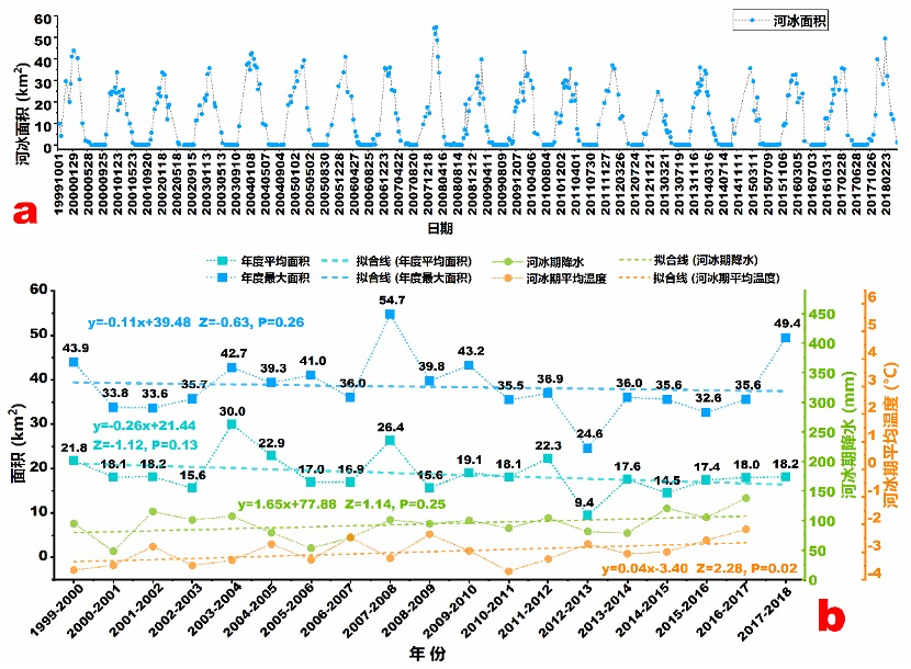
The Cold-Region Remote Sensing Hydrology group at the Northwest Institute of Eco-Environment and Resources, Chinese Academy of Sciences, selected the Babao River basin, a representative alpine catchment in the northeastern Tibetan Plateau, to investigate the spatial and temporal distribution of high-elevation river ice at the basin scale. Using 447 Landsat images acquired during river-ice seasons from 1999 to 2018 and the conventional normalized difference snow index (NDSI), we monitored river ice over a long time series. The mean validation kappa coefficient was 0.973. Mean river-ice area during the ice season showed a slight declining trend and was negatively correlated with air temperature (Figure 1). Gentle slopes and high elevations favored river-ice formation (Figure 2), while spring ice melt supplemented river discharge. This work was the first to reveal basin-scale distribution patterns and trends in river ice on the Tibetan Plateau, providing a reference for further research in the region.
The findings were published in Remote Sensing of Environment. See:
Haojie Li, Hongyi Li, Jian Wang, Xiaohua Hao. (2020). Monitoring high-altitude river ice distribution at the basin scale in the northeastern Tibetan Plateau from a Landsat time-series spanning 1999-2018. Remote Sensing of Environment. 247: 111915. https://doi.org/10.1016/j.rse.2020.111915